Week 3- Earthquakes
For this week's blog, I'll be discussing Ghana's earthquakes and what is done to prevent/prepare for hazards. There are real-time sites you can see to be alert if there were any earthquakes.
Ghana has had damaging earthquakes as far back as 1636 as mentioned. Ghana is not in an earthquake zone but earthquakes do occur. Also, the southern part of the country is seismically active. A study on the microseismic activity in southern Ghana shows that the seismic activity is linked with active faulting between the east-west trending Coastal boundary fault and a northeast-southwest trending Akwapim fault zone.

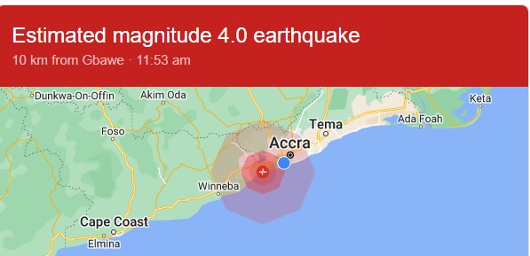
It has been recorded that the worst earthquake that has occurred in Ghana was in 1939 in Accra which is located in the Greater Accra Region. This massive earthquake killed 17 people and caused lots of property damage. The last earthquake and more recent one was on December 12, 2022, which was a 4.0 in magnitude. It happened three times in the period of five times.
What is done to prevent or help during these hazards? The National Disaster Management Organization has come out with a building guide to assist in the mitigation effort of earthquake disasters and floods in the country. Ghana, through the efforts of UNESCO, has received a set of equipment to support its earthquake preparedness efforts.


Very good seismic reflection!
ReplyDelete